Lucia MARSICANO | Domenica DININNO | Fabio REMONDINO
(3DOM – FBK, Trento, Italy)
Keywords: Archaeology, WebGIS, geo-database
Abstract:
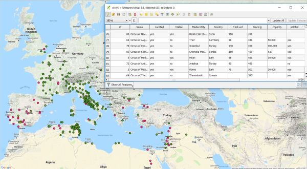
The reported project features the creation of a webGIS containing data about entertainment structures in the whole Roman empire: stadiums, circuses, theaters and amphitheaters. Starting from the study of J. H. Humphrey (1986) and R. G. Chase (2002) who collected information about these typology of buildings during the Roman period, we integrated more recent historical information, together with modern maps and satellite data. The realized geo-database of the Roman structures gives access to information such as localization, name, country, if there are any archaeological remains and if the monument is still visible.
The webGIS will be published in august 2018 on the web site of 3dom (http://3dom.fbk.eu/repository/eta) with open license.
Moreover the results of the presented work are useful to (i) analyze the relationship between buildings and surrounding lands, (ii) perform advanced hypothesis about the accessibility to the structures or the role of these typology of buildings in the urbanistic context, (iii) understand relationship between entertainment and society and (iv) identify concentrations of structures in certain regions.
This research is mostly focused on the circuses, the study of satellite images, published and historical sources allowed to recognize seventysix circuses all over the roman empire. Forty four of these circuses are located and twenty-eight are still visible today.
This data shows the distribution of the circuses in the roman territories and it is interesting to notice that in Italy these structures are rare (except in Rome) but are widespread in Spain (20% of the circuses are in Spain).
Other interesting information concerns the era of construction.
For only forty two circuses the century of construction is known, among these eighteen were builded during the I century CE and seven during the IV century CE.
The buildings constructed during the I century are mostly public, the ones from the IV century are all palatial circuses, that means they are linked to imperial residences.
These are only an example of the possible researches, further studies are in progress.
Relevance for the conference: To demonstrate the potential of a webGIS platform for sharing the collected information about Roman entertainment structures.
Relevance for the session: To create an awareness of the open platform to collect more historical information and allow studies and analyses.
Innovation: The realized web platform, composed of a geo-databases enriched with historical information about Roman structures, could be a useful tool to study and collect data about a complex and weakly studied topics: the geographic distribution of entertainment structures and their relationship with territories.
References:
- J.M. Costa – García, The potential of the Geographic Information Techniques for the analysis of the morphology and settlement patterns of the Roman military sites of early imperial era in Iberia, in V. Mayoral Herrera, C. Parcero – Oubina, P. Fabrega-Alvarez Archaeology and Geomatics, Sidestone Press, 2018
- R. G. Chase, Ancient Hellenistic and Roman amphitheatres, stadiums, and theatres: the way they look now. P. E. Randall, Portsmouth 2002