A spatial Approach to reconstruct Roman Roads in Srem Region
Sara ZANNI | Biljana LUČIĆ | Alessandro DE ROSA
(Université Bordeaux Montaigne, Bordeaux, France)
Keywords: Serbia, satellite remote sensing, Austro-Hungarian maps, GIS
Abstract:
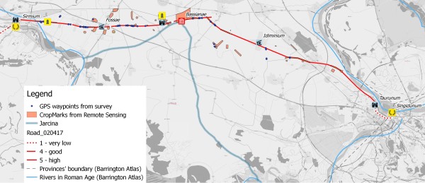
The research presented is part of the project “From Aquileia to Singidunum: reconstructing the paths of the Roman travelers – RecRoad”, developed at Université Bordeaux Montaigne in collaboration with the Institute for Protection of Cultural Monuments of Sremska Mitrovica. The main goal of the project is the detection and reconstruction of the Roman viability connecting the Roman cities of Aquileia (Aquileia, Italy) and Singidunum (Belgrade, Serbia) using different sources and methods, among which are Sentinel-2 multispectral imageries, historical maps and surface survey results. The project provided a first useful testbed for the use of Sentinel-2A images in the archaeological field to detect the presence of buried archaeological sites and remains of Roman roads, with outstanding results in the Srem district (Serbia). The research workflow integrated the remote sensing analysis with the interpretation of historical maps, such as the Josephinische Landesaufnahme (1763-1787), the Franziszeische Landesaufnahme (1808-1869), the Franzisco-Josephinische Landesaufnahme (1869-1887) and the Spezialkarte der Osterreichisch-Ungarischen Monarchie (1877-1914). The historical maps were geo-referenced and overlaid to the satellite imageries inside a GIS platform to succeed in the interpretation of the anomalies detected in the Sentinel-2A images. Finally, a surface survey was performed to check the effective presence of the Roman road traces and of other buried sites. This paper will specifically present the identification of a buried archaeological site connected to the road where it was possible to collect pottery that will allow to date the human activities on the area.
Relevance conference / Relevance session:
The paper shows how it is possible to improve our knowledge of the Roman road network through the integration of modern techniques, such as innovative satellite imageries, and traditional sources.
Innovation:
Beyond the integrated and multi-disciplinary methodology, the paper presents the first attempt to use Sentinel-2A satellite imageries to detect archaeological buried sites.
References:
- Gračanin, H., 2010. Rimske prometnice i ckomunikacije u kasnoantickoj juznoj Panoniji. Scrinia Slavonica, (10), pagg.9–69.
- Molnár, G. & Timár, G., 2009. Mosaicking of the 1:75000 sheets of the Third Military Survey of the Hasburg Empire. Acta Geodaetica et Geophysica Hungarica, 44(1), pagg.115–120.
Figure: