Gunnar SIEDLER | Sebastian VETTER
(fokus GmbH Leipzig, Germany)
Keywords: 3D-Objectdocumentation, textured surface model, ortho projections, 3D mapping
Abstract:
Due to experiences in the field of documentation for heritage conservation and software development the authors have got background knowledge to develop methods for image processing and digital mapping. The aim of the work was a true to scale image plans in the scale of 1:5 to 1:10 for a resolution of 400 dpi. The selection of the right procedure like 3D unwrapping and ortho projection using a digital surface model or textured surface model is always done depending on object geometry and requirements of the conservation project.
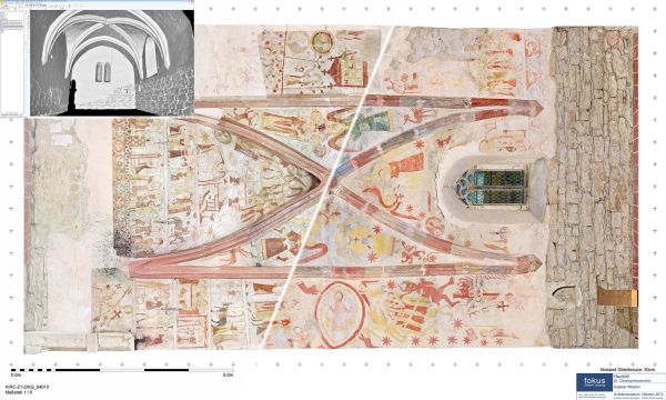
The recording of the object surface by 3D laser scanning or digital photogrammetry (Structure from Motion) is needed for curved surfaces (vaults, apses) and structured or deformed surfaces (walls, ceilings, floors). Both procedures have got advantages and disadvantages that will be shown on several projects.
Today it is possible to create a textured surface model with sufficient image resolution for smaller objects like the vault of the chapel St.Joseph in Isny (13m x 17m). But that assumes appropriate hardware (graphic card) for an efficient evaluation of the data by the user.
The procedures will be explained at different medieval mural painting projects. But they can also be used interdisciplinary for documentation projects, which need high photo quality. In addition to this, it is possible to combine additional images in different colour spaces (like UV light, infrared or historical images) with each of the explained methods.
Due to close cooperation with conservators during development process surface models no longer serve only for presentation but can also be used for true to scale evaluation in the field of conservation. Current developments like the automated image orientation on the base of textured surface models to create multi textured surface models will be shown within this paper.
For 3D mapping on surface models we have developed tools for line and area mapping, that allow cutting of 3D areas, integration of vector symbols and annotations known like in 2D mapping too. Additionally segmentation of large and complex surface models and 2D model views with orthogonal projection for printing output support 3D mapping on surface models.
Relevance conference: The shown procedures are documentation methods for 3D objects that need high photo quality.
Relevance session: The shown procedures are documentation methods for 3D objects, that need high photo quality.
Innovation: The innovation is a multi-textured surface model – that means one surface model with different types of image layers for congruent 3D evaluation.
References:
- Hauffeld church St. Christopherus
- Parish church of St. Martin (Schwyz, Switzerland)