Naoki MORI | Tokihisa HIGO | Kaoru SUEMORI | Hiroshi SUITA | Yoshihiro YASUMURO
(Kansai University, Suita, Japan)
Keywords: Investigation history, (SfM) Structure from Motion, PnP Problem
Abstract:
This paper is motivated by work at “Barbar Temple,” which is one of the significant archaeological sites in the Kingdom of Bahrain. This site dating back to the 3rd millennium BCE belongs to the ancient Dilmun civilization which has a relation with the Mesopotamian and Indus civilizations. This remarkable site has been required to protect and listed on the Tentative List of UNESCO World Heritage. The documentation of Barbar Temple has been started since the first excavations by Danish mission in the 1950s -1960s. There is a possibility
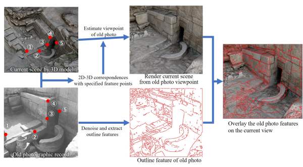
to grasp the changes and damages of the site caused by environmental or human factors over the decades by utilizing the photographs taken in the past. As a case study to apply 3D digitalization for protecting the archaeological site, this paper proposes a methodology for collation of the ‘past photographs’ and current physical appearance. The process of this method consists of three steps; 1) estimate 3D position and the orientation of the camera by which ‘past photographs’ were taken; 2) make corresponding pairs between ‘past photographs’
and the 3D data of current site; 3) render a CG model of the current site from the viewpoint of the estimated camera position and orientation; 4) overlay the CG with the ‘past photographs’ on the same view. This paper applied the method to the ‘pool’ area of Barbar Temple, which was a pivotal facility of the temple with a sacred spring used for worship of Sumerian water god Enki. It was expected that the piled-up blocks of the stone construction surrounding the spring has caused strains on itself and changed its appearance. This methodology enabled us not only to grasp the changes in the whole appearance of this area easily but also to find the slight changes in the orientations of the stones quantitatively.
Relevance for the conference: Our work aims to develop a methodology of using 3D digital reconstructions as research tools to associate the old photo records to the current as-is information of the archaeological site.
Relevance for the session: The first author is a master course student in graduate school of Science and Engineering.
Innovation: This paper addresses a methodology to support the collation of photo data taken in the past and the current presence by image processing.
References:
- P. Rodríguez-Gonzálvez and A. L. Muñoz-Nieto and S. del Pozo and L. J. Sanchez-Aparicio and D. Gonzalez-Aguilera and L. Micoli and S. Gonizzi Barsanti and G. Guidi and J. Mills and K. Fieber and I. Haynes and B. Hejmanowska, 4D RECONSTRUCTION AND VISUALIZATION OF CULTURAL HERITAGE: ANALYZING OUR LEGACY THROUGH TIME, ISPRS – International Archives of the Photogrammetry, Remote Sensing and Spatial Information Sciences, vol. XLII-2/W3, pp.609-616, 2017.
- B. Hejmanowska, E. Głowienka, P. Opaliński, S. Mikrut, K. Michałowska, and P. Kramarczyk, “4D Reconstruction and Visualisation of Krakow Fortress,” in 2017 Baltic Geodetic Congress (Geomatics) : proceedings of a meeting held 22-25 June 2017, Gdansk, Poland., pp. 1–5, 2017.