Helena SEIDL DA FONSECA1 | Julia KLAMMER2
(1Kuratorium Pfahlbauten | 2Universität Vienna, Vienna, Austria)
Keywords: GIS, documentation, 3D visualisation/modelling, underwater archaeology, cultural heritage
Abstract:
The existence of many archaeological sites are widely known among researchers, but they haven’t yet been excavated or even mapped. When they are investigated as part of recent research, we always hope to uncover proper and accurate documentation from older initatives. Until the last decade, this was mostly done in an analogue way, but nowadays we gather data predominantly by digitally recording it. So, if someone intends to research of a known site, they are usually faced with old, analogue records that have to be brought up to the basic level so as to conform to standards of modern documentation, and within a current working environment this means digital documentation.
Site and profile drawings of archaeological features are generally very useful to record spatial context of archaeological structures. To match old drawings with newly acquired data, it is necessary to digitise and georeference them. But profiles in particular tend to be difficult in terms of reworking and positioning in the correct spatial position. In this lecture we want to present and discuss methods of how to facilitate this kind of data integration. We will share our experiences of dealing with two kinds of datasets that have to be merged and properly visualised so as to provide new insights into old projects.
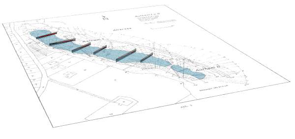
Using the example of the underwater cultural heritage of prehistoric pile dwellings in Austria we show how data accumulations of analogue documentation can be included in a GIS-based 3D environment and incorporated with modern data.
Especially in these cases, profile drawings can reveal substantial archaeological information and can be seen as essential for 3D modelling of these sites. In addition, these data provide a basis for monitoring sites and for decision making processes (e.g. for the selection of future survey areas or the location of future underwater excavations).
Relevance for the conference: The GIS-based 3D evaluation of analogue documentation and new digital datasets show how archived data can be brought back to life, providing important insights into current projects dealing with historic cultural heritage sites.
Relevance for the session: The incorporation of analogue datasets into a GIS-based 3D environment is a topic a lot of archaeologists are confronted with and shows, when successfully performed, how former documentation can support preparatory work in Archaeology.
Innovation: Presenting new expert solutions to known issues when incorporating and integrating analogue data from older projects into modern GIS-based 3D environments.
References:
- https://beyondlakevillages.wordpress.com
- https://www.pfahlbauten.at/projekte/zeitensprung
- http://hallstatt-forschung.blogspot.com/search?q=profile